Hiking

Medium

Tschirgant (No. 24)

Hiking

Hiking tour

08:30 h

1162 hm

1592 hm

2332 m

Information

Course: Karröster Alm - Tschirgantsteig - Tschirgant 

 
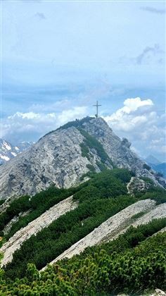
From the Karröster Alm, you set off on a gentle path across picturesque alpine meadows. Soon, the climb begins, and you enter a shady mountain forest. Especially in early and summer, you'll be accompanied by vibrant alpine roses – a veritable sea of flowers! The path winds its way pleasantly, with small clearings opening up every now and then, offering impressive views of the surrounding mountains. Here, you can take a moment to breathe and enjoy the peace and quiet. At a junction, keep straight ahead. From here, the path becomes noticeably steeper. You'll pass through the last stands of Swiss stone pine and larch before emerging above the tree line. Up there, the final climb to the ridge awaits – it's worth it, as you'll be rewarded with a stunning 360° panorama of the Tyrolean mountains. On the ridge, keep left. From there, you'll already see the Haiminger Kreuz (2,232 m), the highest point of this tour. It's not far now! The final section is a bit rockier, so surefootedness is required. Once you reach the top of the Haiminger Kreuz, you'll enjoy a stunning panoramic view of the surrounding mountains – simply spectacular! After the summit experience, there's a short, gravelly descent – please be especially careful here, as there's a risk of slipping. After that, the walk continues at a leisurely pace, gently uphill and downhill over the rolling hills of the Simmering. Dense, characteristic pine fields accompany you – a true nature experience! You'll soon reach the Haiminger Alm, where you can take a short rest. Refreshed, it's then a further climb to the Simmering, the second highest point of the tour. From the Simmering, the trail descends across wide alpine meadows to the Simmering Alm. From there, you continue on a narrow, idyllic forest path down to the Grünberglift in Obsteig, where your hike ends.

Features & Characteristics

Stamina

Skill

Start Point

Karröster Alm

End Point

Tschirgant

Map & Elevation Profile

Similar Tour Suggestions

Mils_Starkenbach-1.jpg

Medium

Hiking

Section 2: Kronburg - Mils

Long distance trails

6,60 km

02:00 h

71 hm

270 hm

963 m

2015-Schwimmen & Tauchen-Starkenberger See-Tarrenz-©Unbekannt (16).jpg

Easy

Hiking

Starkenberger See

Hiking tour

Loop Hike

5,00 km

02:00 h

106 hm

110 hm

900 m

imst_tourismus_wandern_wyhlidal_west_0004.jpg

Easy

Hiking

Adlerhorststeig

Hiking tour

4,00 km

01:30 h

202 hm

199 hm

1116 m

im_blauegrotte_001.jpg

Easy

Hiking

Blue Grotto (No. 9)

Hiking tour

Loop Hike

6,80 km

02:30 h

393 hm

1296 m

Fernstein - Fernpaßhöhe.jpg

Easy

Hiking

Fernstein - Fernpaßhöhe

Hiking tour

3,60 km

01:50 h

303 hm

35 hm

1212 m

WF_Imst_T06_IMG_05_6273_Plott.jpg

Easy

Hiking

Hachleschlucht

Hiking tour

4,40 km

02:30 h

298 hm

1051 m

Kappakreuz.jpg

Medium

Hiking

Kappakreuz

Hiking tour

1,40 km

02:30 h

403 hm

1234 m

scharnitzsattel_richtung_imst.jpg

Medium

Hiking

Scharnitzsattel (Muttekopfhütte)

Hiking tour

2,30 km

02:00 h

500 hm

2441 m

tirolimster-bergbahnenAlpine Coaster Logoarea47trustyou